


Marine Ways - Nautical Charts
Beschreibung von Marine Ways - Nautical Charts
Diese Anwendung ist nicht mit der NOAA verbunden und vertritt keine staatliche Stelle.
Diese App verwendet frei verfügbare Karten von NOAA und anderen unten aufgeführten Quellen.
https://charts.noaa.gov/ENCs/ENCs.shtml
https://www.linz.govt.nz/
https://www.weather.gov/
Haftungsausschluss für Navigationskarten der NOAA:
NOAA ENC Online ist nicht für die Navigation zertifiziert. Die hier angezeigten Screenshots der ENCs erfüllen NICHT die Anforderungen an die Mitnahme von Karten für regulierte Handelsschiffe gemäß den Titeln 33 und 46 des Code of Federal Regulations.
Marine Ways Boating ist die ultimative Navigations- und Planungsanwendung für das Meer! In dieser Anwendung erhalten Sie Zugriff auf:
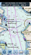
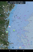
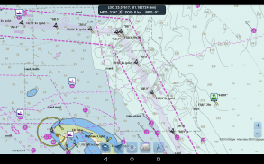
NAVIGATIONSKARTEN
- Karten der Vereinigten Staaten, bereitgestellt von der National Oceanic and Atmospheric Administration (NOAA)
https://charts.noaa.gov/ENCs/ENCs.shtml
- Neuseeland-Karten bereitgestellt von Land Information New Zealand (LINZ)
https://www.linz.govt.nz/
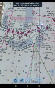
Diagrammtypen:
- NOAA Electronic Navigational Charts (ENC) (NOAAs neuestes und leistungsstärkstes elektronisches Kartenprodukt).
https://charts.noaa.gov/ENCs/ENCs.shtml
https://nauticalcharts.noaa.gov/
- Klassische NOAA-Karten (einschließlich Versionen für Tag, Rot, Dämmerung, Nacht und Grau).
- LINZ-Karten (derzeit nur in den Versionen Tag, Dämmerung und Nacht verfügbar)
https://www.linz.govt.nz/
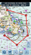
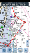
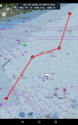
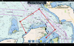
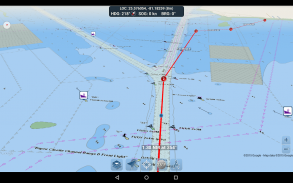
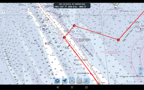
ROUTENPLANUNGSTOOLS
-Routenplanung. Tippen Sie eine Sekunde lang auf die Karte, um Ihre Wegpunkte einzuzeichnen. Um eine Route zu erstellen, tippen und halten Sie in verschiedenen Bereichen weiterhin auf die Karte. Entfernung und Peilung werden bequem berechnet und für jede Etappe angezeigt, während Sie Wegpunkte hinzufügen, anpassen oder entfernen.
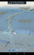
-Reisemodus. Zentriert die Karte automatisch auf Ihre aktuelle Position, während Sie sich bewegen. Verwenden Sie den Reisemodus, um in Echtzeit zu sehen, wie genau Sie Ihrer geplanten Route folgen!
-Zusammenfassung der Streckenabschnitte. Eine praktische Ansicht mit detaillierten Informationen zu jedem von Ihnen aufgezeichneten Abschnitt, einschließlich Start- und Endkoordinaten, Entfernung und Peilung.
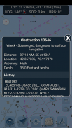
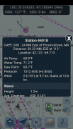
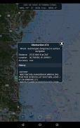
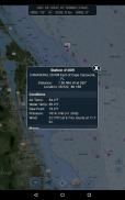
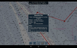
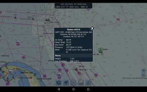
BOJENBERICHTE UND HINDERNISINFORMATIONEN
Daten erhalten von: https://www.weather.gov/
Markierungen für Bojen und Hindernisse werden bequem an ihrer tatsächlichen Position auf der Karte eingezeichnet! Klicken Sie einfach auf die Markierung, um deren Informationen anzuzeigen!
- Bojenberichte: Erhalten Sie vollständige aktuelle Bedingungen und Wellenberichte für feste und treibende Bojen.
https://www.weather.gov/
- Hindernisse: Erhalten Sie Standort- und Verlaufsinformationen zu potenziell gefährlichen, untergetauchten Gefahren, einschließlich Felsen und versunkenen Schiffen.
https://www.weather.gov/
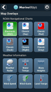
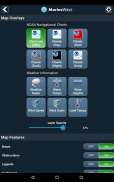
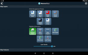
Meereskarten-Overlays
Schalten Sie verschiedene Meeres-Overlay-Daten direkt auf der Karte ein, um eine bessere Vorstellung von den aktuellen Bootsbedingungen zu erhalten!
Zu den Overlays gehören:
- Wasseroberflächentemperatur (global)
- Windgeschwindigkeiten (nur USA)
- Windböen (nur USA)
- Wave Heights (nur USA)
https://www.weather.gov/
STANDORTTEILUNG ÜBER WASSER / ANDERE BOOTE ANZEIGEN
- Zeigen Sie Ihren letzten bekannten Standort, Ihre Geschwindigkeit, Ihre Peilung und Ihren Bootsnamen auf der Karte an, damit andere Marine Ways-Bootsfahrer sie sehen können.
- Zeigen Sie den letzten bekannten Standort, die Geschwindigkeit, die Peilung und den Bootsnamen anderer Marine Ways-Bootsfahrer sowie deren Entfernung und Peilung von Ihrem Standort an.
- Die Standortfreigabe ist standardmäßig deaktiviert. Wenn Sie zum Teilen bereit sind, schalten Sie es in den allgemeinen Einstellungen ein. Um Ihren Standort auf der Karte kontinuierlich zu aktualisieren, halten Sie die App geöffnet und fokussiert. Die App aktualisiert Ihren Standort derzeit nicht im Hintergrund.
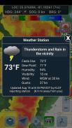
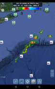
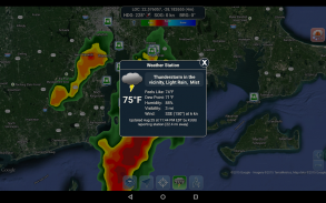
WETTERINFORMATIONEN
- Wetter-Niederschlagsradar (nur USA und Hawaii). Erkennt Regen und Schnee in der Umgebung.
- Wetterstation. Meldet die Daten der nächstgelegenen Beobachtungsstation. Aktuelle Temperatur, Luftfeuchtigkeit, Wetterbedingungen, Wind und mehr! Stationsbeobachtungsdaten sind weltweit verfügbar.
- Überlagerung der Landoberflächentemperatur. Zeigt die aktuelle Oberflächentemperatur an Land (nur USA).
Bevor Sie diese Anwendung verwenden, lesen Sie bitte die folgenden Nutzungsbedingungen/Service- und Datenschutzbestimmungen und stimmen Sie ihnen zu:
Nutzungsbedingungen/Service: http://www.marineways.com/appterms
Datenschutzrichtlinie: http://www.marineways.com/appprivacy
Viel Spaß mit der App! Marine Ways ist auch im Internet unter http://www.marineways.com verfügbar
Marine Ways - Nautical Charts – Version 1.75
(02-04-2025)Marine Ways - Nautical Charts – APK Informationen
APK Version: 1.75Paket: com.marineways.androidNeueste Version von Marine Ways - Nautical Charts
Weitere Versionen


Apps in derselben Kategorie

Das könnte dir auch gefallen...


